Lista przedmiotów z materiałami udostępnionymi dla studentów
- Medical Imaging, prof. dr hab. M. Strzelecki
- Law and Ethics in Bio-Medical Engineering, George R. Brown
- Final Project Seminar, prof. dr hab. M. Strzelecki


| System do zdalnego śledzenia obiektów z wykorzystaniem platformy Java 2 Micro Edition, systemu GPS, map cyfrowych terenu oraz sieciowych protokołów transmisji danych |
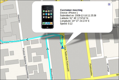
Autor pracy: Paweł WierzbickiOpiekun: dr hab. Paweł Strumiłło, prof. PŁ Wyróżnienie w konkursie na najlepszą pracę magisterską wykonaną w roku akademickim 2008/2009, organizowanym przez Zarząd Oddziału Łódzkiego SEP i Wydział Elektrotechniki, Elektroniki, Informatyki i Automatyki Politechniki Łódzkiej. The aim of this master thesis is to demonstrate that a low cost, yet powerful and feature rich, mobile device tracking system can be created using various free and open-source technologies. The system will use a GPS enabled mobile device to collect location information and submit them over an IP mobile network to a server. The server will store that information in a database. Another part of the system – the web front-end will allow
Relevance of such system can be easily recognised in numerous areas - from commercial The system can be divided into three segments – the mobile application, the server backend and web front-end. The mobile application is written in Java programming language that uses Java 2 Micro Edition (J2ME) platform and can be run on most modern mobile devices. The server runs Linux operating system which hosts MySQL database server and Apache web server. The web front-end is built with PHP scripting language with aid of JavaScript. It uses Google Maps as digital maps provider. The mobile application communicates with the server through a SOAP webservice, the front-end is interpreted by the web server from the PHP scripts and sent to any web browser using HTTP protocol. I was able to achieve full desired functionality of the system. All segments worked together perfectly. The mobile application was installed on a Blackberry Curve 8310 mobile smartphone. It collected location information from its built in GPS receiver and sent them to the server. The front-end was able to successfully track the device and display its location and path in real time on digital Google maps. The system also includes several additional features – tracking several devices simultaneously, access to each mobile device movements’ history, defining and submitting events from the mobile device, reverse geocoding (converting numerical location to an address), data transfer and energy saving algorithms in the mobile application. |